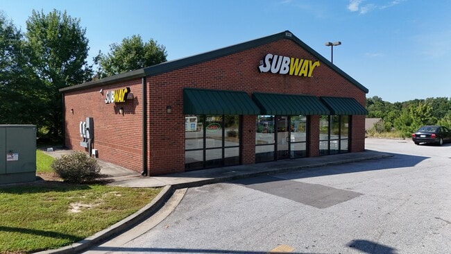
Property Record
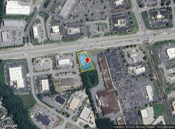
2120 Friendship Rd, Buford, GA 30519
Current Lease Availabilities
NEARBY LISTINGS FOR SALE OR LEASE
Property Detail
2120 Friendship Rd
15-00041-00-149
Friendship Springs Vil 2
Restaurantdrivein
SPOUT SPRINGS ROAD
X
Hall
13139C0357G
Georgia
2025
0.58 AC
2025
Gainesville/Hall Cnty
001605
Atlanta
1,845 SF
Gainesville, GA
DEMOGRAPHICS near 2120 Friendship Rd
1 Mile
3 Mile
5 Mile
2024 Total Population
5,406
37,651
99,113
2029 Population
5,775
40,259
106,487
Pop Growth 2024-2029
+ 6.83%
+ 6.93%
+ 7.44%
Average Age
39
41
40
2024 Total Households
1,685
12,374
32,060
HH Growth 2024-2029
+ 6.88%
+ 7.20%
+ 7.65%
Median Household Inc
$129,059
$122,904
$113,919
Avg Household Size
3.10
3.00
3.00
2024 Avg HH Vehicles
2.00
2.00
2.00
Median Home Value
$469,719
$463,464
$448,049
Median Year Built
2004
2006
2005
Nearby Places
- Restaurants
- Banks
- Shops
- Fitness
- Groceries
Nearby Properties
Address
Land Use
TOTAL SIZE
Lot Size
Zoning
Address
Land Use
TOTAL SIZE
Lot Size
Zoning
473,883 SF
85.71 AC
RA200
Address
Land Use
TOTAL SIZE
Lot Size
Zoning
105,000 SF
104.18 AC
POD
Address
Land Use
TOTAL SIZE
Lot Size
Zoning
379,680 SF
76.71 AC
R100
Address
Land Use
TOTAL SIZE
Lot Size
Zoning
372,813 SF
172.70 AC
RA200
Address
Land Use
TOTAL SIZE
Lot Size
Zoning
273,101 SF
126.33 AC
PRD
Address
Land Use
TOTAL SIZE
Lot Size
Zoning
404,091 SF
58.20 AC
RA200
Address
Land Use
TOTAL SIZE
Lot Size
Zoning
30,720 SF
12.28 AC
G-C
Address
Land Use
TOTAL SIZE
Lot Size
Zoning
263,400 SF
8.65 AC
PRD
Address
Land Use
TOTAL SIZE
Lot Size
Zoning
114,835 SF
15.29 AC
POD
Address
Land Use
TOTAL SIZE
Lot Size
Zoning
23,126 SF
88.56 AC
RA200
Address
Land Use
TOTAL SIZE
Lot Size
Zoning
46,400 SF
3.51 AC
G-C
Address
Land Use
TOTAL SIZE
Lot Size
Zoning
44,824 SF
3.22 AC
G-C
Address
Land Use
TOTAL SIZE
Lot Size
Zoning
24,486 SF
3.85 AC
G-C
Address
Land Use
TOTAL SIZE
Lot Size
Zoning
82,604 SF
13.11 AC
G-C
Address
Land Use
TOTAL SIZE
Lot Size
Zoning
31,094 SF
126.02 AC
RA200
Address
Land Use
TOTAL SIZE
Lot Size
Zoning
71,951 SF
8.78 AC
PRD
Address
Land Use
TOTAL SIZE
Lot Size
Zoning
1,280 SF
24.21 AC
PCD
Address
Land Use
TOTAL SIZE
Lot Size
Zoning
42,848 SF
4.55 AC
G-C
Address
Land Use
TOTAL SIZE
Lot Size
Zoning
24,490 SF
8.30 AC
C2
Address
Land Use
TOTAL SIZE
Lot Size
Zoning
15,000 SF
7.53 AC
G-C
Address
Land Use
TOTAL SIZE
Lot Size
Zoning
35,318 SF
6.72 AC
G-C
Address
Land Use
TOTAL SIZE
Lot Size
Zoning
94,098 SF
1.83 AC
MUNI
Address
Land Use
TOTAL SIZE
Lot Size
Zoning
17,900 SF
21.18 AC
RA200
Address
Land Use
TOTAL SIZE
Lot Size
Zoning
8,204 SF
5.25 AC
G-C
Address
Land Use
TOTAL SIZE
Lot Size
Zoning
24,500 SF
10.71 AC
RA200
Address
Land Use
TOTAL SIZE
Lot Size
Zoning
191.82 AC
PUD
Address
Land Use
TOTAL SIZE
Lot Size
Zoning
1,412 SF
43 AC
OI
Address
Land Use
TOTAL SIZE
Lot Size
Zoning
93,158 SF
2.04 AC
PRD
Address
Land Use
TOTAL SIZE
Lot Size
Zoning
29,212 SF
2.64 AC
N-C
Address
Land Use
TOTAL SIZE
Lot Size
Zoning
17,110 SF
5.73 AC
PCD
The World's #1 Commercial Real Estate Marketplace
Connect with us
© 2025 CoStar Group
The information above has been obtained from sources believed reliable. While we do not doubt its accuracy we have not verified it and make no guarantee, warranty or representation about it. It is your responsibility to independently confirm its accuracy and completeness. Any projections, opinions, assumptions, or estimates used are for example only and do not represent the current or future performance of the property. The value of this transaction to you depends on tax and other factors which should be evaluated by your tax, financial, and legal advisors. You and your advisors should conduct a careful, independent investigation of the property to determine to your satisfaction the suitability of the property for your needs.